Upwelling? 🌬️
Upwelling is the upward of sea water from deeper levels, colder and richer in nutrients (nitrates, phosphates and silicates). This water replaces the surface water, warmer and generally poorer in nutrients, which has been displaced by the action of the wind.
If this phenomenon takes place near the coast it is called coastal upwelling and if it occurs in the open sea it is called oceanic upwelling.
How it woks?
When the wind blows over the sea surface, the surface water layer tends to move in the same direction. As the hours pass and due to the Earth's rotation, this surface layer undergoes a deviation of its trajectory to the right in the Northern hemisphere, or to the left if we are in the Southern hemisphere (Coriolis effect).
Coastal upwelling in the northern hemisphere occurs when the wind blows parallel to the coast and the coast is to the left of its direction. In this case, the transport of the surface layer of water is towards the open sea, generating a vacuum on the coast that induces upwelling (upwelling of subsurface waters, between 50 and 100 m deep). These waters are colder and richer in nutrients, contributing to fertilize the surface layers.
How is their intensity estimated?
The drag of surface water due to the wind and the Coriolis effect are felt up to a depth at which the fluid velocity with respect to the surface is considered minimum. The integrated transport of water from the surface to that depth is called Ekman transport and is perpendicular to the wind direction Ekman (1905).
Bakun (1973), based on the studies of Ekman, described the so-called “upwelling index”. This index makes it possible to infer the flow of water upwelling on the coast from the volume of surface water displaced by the wind. Such transport depends on latitude and wind stress on the sea surface.
The deforming effect of the wind on the sea surface (wind stress) can be calculated from its speed and direction:
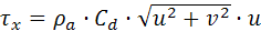
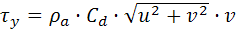
Where ρa is the density of air, Cd is the drag coefficient of air, u and v are the wind speed components.
The volume of water displaced by the wind and per linear km of coastline (m3s-1 km-1) in the west-east (Qx) and south-north (Qy) directions, can be calculated using the equations:
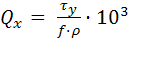
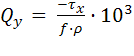
Where f is the Coriolis factor which is dependent on latitude (e.g., 9.94·10-5 s-1 for latitude 43ºN) and ρ is the density of seawater.
The upwelling index is defined positive offshore. This means that along the Atlantic coast of the Iberian Peninsula, the upwelling index is equal to -Qx.
43ºN, 11ºW. A historic reference off Northwest Iberia
During many years, Lavín et al. (1991) computed the daily upwelling index at 43ºN 11ºW, considered as representative of the upwelling intensity on the west coast of Galicia (Rías Baixas).
To do this task, they deduced the geostrophic winds from sea level pressure maps (3 times/day). Winds were rotated 15º through low pressures and the module decreased a 30% due to friction.
This reference locations is still used in many oceanographic studies. In this web, you can find it as the 'Fisterra station'.
The upwelling in Galicia (Northwest Spain)
The Rías Baixas are particularly productive areas from which significant quantities of fish and shellfish are extracted annually due to the presence of seasonal upwelling.
That is why it is of interest to have an estimate of upwelling index, as it gives us an indication of the biomass that can be produced annually, as well as to plan the exploitation of coastal resources.
On the Atlantic coast of Galicia, upwelling occurs predominantly during the summer season, when the wind blows from the north. As described above, this phenomenon allows new nutrients to be placed in the surface layers and therefore with more light, fertilizing the waters.
When the wind blows from the south, often in autumn and winter, it drags the surface layer towards the northeast and the Ekman transport generated produces a pile-up of oceanic water against the coast and favors the sinking of surface waters. This process tends to retain coastal waters in its inner zone and within the estuaries, decreasing the possibilities of fertilization.
Due to the change of orientation of the coastline, the Cantabrian shelf is affected by upwelling when the wind blows from the east, while the predominant westerly winds generate episodes of subsidence on this coast. The orientation of the coastline is taken into account in the computations shown in this web.
References
Bakun, A., 1973. Coastal upwelling indices, west coast of North America, 1946-71, U.S.Dep. Commer., NOAA Tech. Rep., NMFS SSRF-671, 103 p.
Ekman, V. W., 1905. On the influence of the earth’s rotation on the ocean currents. Arkiv for Mathematik, Astronomi och Fysik, 2 (11), 52p.
Lavín, A., Diaz del Rio, G., Cabanas, J. M., Casas, G., 1991. Afloramiento en el Noroeste de la Peninsula Iberica. Indices de afloramiento para el punto 43º N 11º W. Periodo 1966-1989. Informes Técnicos del Instituto Español de Oceanografía, 91: 1-40.